|
Following up on the previous post about exploring the Darksky API, I've developed a short notebook that allows for the collection of near-real-time data from geostationary satellites. The launch of the GOES-R satellites in 2016 came with (I collect) heaps of excitement from the earth imaging community, as these satellites provide real-time, high-resolution imagery from a number of channels of interest. A bunch of these tools are overlayed on maps by the RealEarth project out of the University of Wisconsin-Madison, and one cool use that is not dissimilar from mine is the FogToday project by Logan Williams. GOES satellite imagery is stored in a number of places, including AWS and the Google Cloud, both of which keep ~100 Terabyte (something like 120-day) historical datastreams for download. RealEarth has a much smaller dataset, on the order of a few days, but it has a very simple API and by building a pipeline that periodically collects data from the API it should be possible to build imagery databases over time. That seems like a good starting point, so in this linked notebook I show how to collect specific imagery data (in this case, cloud/fog data) from the API. These images are then read in and converted to flattened numpy arrays, which can be used for downstream applications such as ML. Below is an example image, from August 8, 2018 at 5pm, centered on San Francisco and imaged in the G16-ABI-CONUS-BAND02 channel. As you can see, Karl is making an appearance. 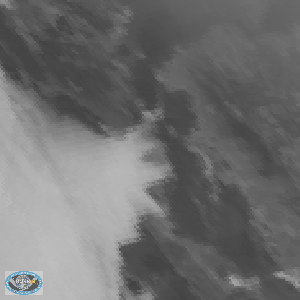
0 Comments
Leave a Reply. |
AuthorWrite something about yourself. No need to be fancy, just an overview. ArchivesCategories |
 RSS Feed